South View from Paritutu Rock in HDR
MAP
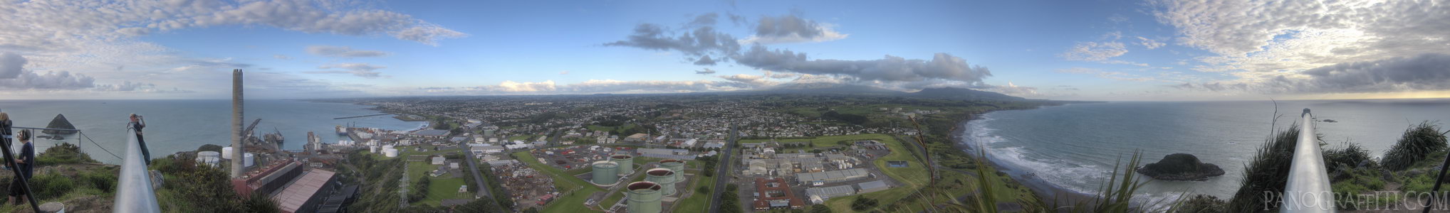
Paritutu Rock is in the Eastend Reserve and offers a 360 degree view of New Plymouth
Beach
City
Coast
Lookout
Mountain
Sky
Volcano
May 21st, 2011 on Saturday at 4:12 PM
30.2MP
27mm f4.0 323/s ISO80
Taranaki, Taranaki, New Zealand
administrative_area_level_1=Taranaki country=New Zealand
20 places and 124 pans within 247 km
Tongariro National Park - 128 km East
Manawatu-Wanganui, New Zealand
Tongariro Alpine Crossing - 136 km East
Tongariro National Park, Manawatu-Wanganui, New Zealand
Desert Road - 146 km East
Manawatu-Wanganui, New Zealand
Manawatu-Wanganui - 147 km South-East
Manawatu-Wanganui, New Zealand
Lake Taupo - 177 km East
Taupo, Waikato, New Zealand
Waikato River - 179 km East
Taupo, Waikato, New Zealand
Taupo - 182 km East
Waikato, New Zealand
Wai-O-Tapu - 214 km East
Waiotapu, Bay of Plenty, New Zealand
Bay of Plenty - 228 km North-East
Bay of Plenty, New Zealand
Auckland - 255 km North
Auckland, New Zealand
Kapiti Coast - 226 km South
Wellington, New Zealand
Abel Tasman National Park - 224 km South-West
Tasman, New Zealand
Hawke's Bay - 268 km East
Hawke's Bay, New Zealand
Coromandel Peninsula - 288 km North-East
Waikato, New Zealand
Cathedral Cove - 290 km North-East
Waikato, New Zealand
Picton - 247 km South
Marlborough, New Zealand
Wellington Harbour - 254 km South
Wellington, New Zealand
Wellington - 255 km South
Wellington, New Zealand
Mount Victoria - 256 km South
Wellington, New Zealand
Motueka - 247 km South
Tasman, New Zealand
10 pans at Taranaki
Mount Taranaki Reflected on Lake Mangamahoe
Mount Taranaki from Paritutu Hill
East From Paritutu Rock
Orange Dot in Paritutu Centennial Park
SS Gairloch Shipwreck
Lake Mangamahoe and Mount Taranaki
Paritutu Centennial Park Sunset
Paritutu Centennial Park Sunset Dark
Awakino River in King Country
Back 1 of 10
Taranaki
Taranaki, New Zealand
You are at the 2nd of 10 panoranics
Click on the panoramic to zoom in
or select an option from the side
Next 3 of 10
Back
Close
## of ###
Visit
Next


 Back 1 of 10


 Close
Close

