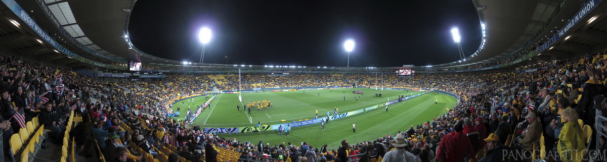
Rugby World Cup 2011
MAP
Watching the Australia destroy the USA during the world cup, doesn't matter as the kiwis were all chearing for not-Australia anyways
Building
September 23rd, 2011 on Friday at 8:12 PM
43.3MP 207x52 Cylindrical
27mm f2.0 60/s ISO125
Wellington, Wellington, New Zealand
20 places and 114 pans within 312 km
Mount Victoria - 3 km South-East
Wellington, New Zealand
Wellington Harbour - 3 km East
Wellington, New Zealand
Lyall Bay - 8 km South
Wellington, New Zealand
Kapiti Coast - 38 km North-East
Wellington, New Zealand
Cape Palliser - 41 km South-East
Wellington, New Zealand
Picton - 65 km West
Marlborough, New Zealand
Motueka - 151 km West
Tasman, New Zealand
Abel Tasman National Park - 151 km West
Tasman, New Zealand
Kaikoura - 155 km South-West
Canterbury, New Zealand
Manawatu-Wanganui - 164 km North
Manawatu-Wanganui, New Zealand
Nelson Lakes National Park - 172 km West
Nelson, New Zealand
Tongariro National Park - 239 km North
Manawatu-Wanganui, New Zealand
Desert Road - 248 km North
Manawatu-Wanganui, New Zealand
Tongariro Alpine Crossing - 249 km North
Tongariro National Park, Manawatu-Wanganui, New Zealand
Taranaki - 268 km North-West
Taranaki, New Zealand
Punakaiki - 291 km West
West Coast, New Zealand
Hawke's Bay - 298 km North-East
Hawke's Bay, New Zealand
Christchurch - 308 km South-West
Canterbury, New Zealand
Lake Taupo - 306 km North
Taupo, Waikato, New Zealand
Banks Peninsula - 312 km South-West
Canterbury, New Zealand
10 pans at Wellington
Abandoned Chest Hospital Theater Room
Wellington Cable Car
Solace of the Wind Statue
Illuma Light Show
Wellington Harbor From Waitangi Park
Bathroom in Chest Hospital
Wellington Central Firestation
Wellington Harbor Night Shot
All Blacks vs South Africa at Westpack Stadium
Back 4 of 10
Wellington
Wellington, New Zealand
You are at the 5th of 10 panoranics
Click on the panoramic to zoom in
or select an option from the side
Next 6 of 10
Back
Close
## of ###
Visit
Next


 Back 4 of 10


 Close
Close

