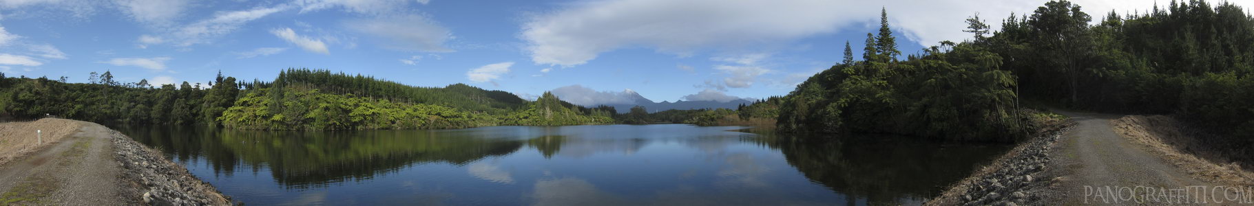
Lake Mangamahoe and Mount Taranaki
MAP
A 180 degree view of Lake Mangamahoe with the north face of Mount Taranaki in the background.
Lake
Mountain
May 21st, 2011 on Saturday at 12:57 PM
32.7MP 237x38 Cylindrical
27mm f5.0 500/s ISO80
Taranaki, Taranaki, New Zealand
administrative_area_level_1=Taranaki country=New Zealand
20 places and 124 pans within 243 km
Tongariro National Park - 122 km East
Manawatu-Wanganui, New Zealand
Tongariro Alpine Crossing - 131 km East
Tongariro National Park, Manawatu-Wanganui, New Zealand
Desert Road - 141 km East
Manawatu-Wanganui, New Zealand
Manawatu-Wanganui - 139 km South-East
Manawatu-Wanganui, New Zealand
Lake Taupo - 175 km East
Taupo, Waikato, New Zealand
Waikato River - 177 km East
Taupo, Waikato, New Zealand
Taupo - 179 km East
Waikato, New Zealand
Wai-O-Tapu - 212 km North-East
Waiotapu, Bay of Plenty, New Zealand
Bay of Plenty - 228 km North-East
Bay of Plenty, New Zealand
Auckland - 260 km North
Auckland, New Zealand
Kapiti Coast - 218 km South
Wellington, New Zealand
Abel Tasman National Park - 220 km South-West
Tasman, New Zealand
Hawke's Bay - 263 km East
Hawke's Bay, New Zealand
Coromandel Peninsula - 292 km North-East
Waikato, New Zealand
Cathedral Cove - 293 km North-East
Waikato, New Zealand
Picton - 241 km South
Marlborough, New Zealand
Wellington Harbour - 246 km South
Wellington, New Zealand
Wellington - 248 km South
Wellington, New Zealand
Mount Victoria - 248 km South
Wellington, New Zealand
Motueka - 243 km South-West
Tasman, New Zealand
10 pans at Taranaki
Mount Taranaki Reflected on Lake Mangamahoe
South View from Paritutu Rock in HDR
Mount Taranaki from Paritutu Hill
East From Paritutu Rock
Orange Dot in Paritutu Centennial Park
SS Gairloch Shipwreck
Paritutu Centennial Park Sunset
Paritutu Centennial Park Sunset Dark
Awakino River in King Country
Back 6 of 10
Taranaki
Taranaki, New Zealand
You are at the 7th of 10 panoranics
Click on the panoramic to zoom in
or select an option from the side
Next 8 of 10
Back
Close
## of ###
Visit
Next


 Back 6 of 10


 Close
Close

